Illegal Yellow Trail
After walking up Raven Lake Road from the trailhead at the end of Necessary Dam Road, the easy part of my trip is over, with the bushwhacking portion set to begin. The Shallow Pond Canoe Carry acts as my starting point, but it will not be long before striking out on my own and entering into the surrounding Five Ponds Wilderness to reach the western shore of Raven Lake. Camping along Raven Lake’s shoreline should provide some opportunities to record some water bird species for the Birdathon tomorrow morning.
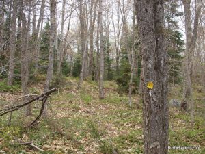
With a short rest after my hike up along the road made even shorter by the horde of black flies hovering around my head, I start off north following the Shallow Pond Canoe Carry. Before going too far, the trail is all but lost, either because it gets little use or my eagerness to start bushwhacking gets the best of me. Probably, just lack of use. This is the last marked trail I would see for the rest of my trip, other than a few fragments of an old hunters’ paths, or so I thought.
The going is fairly easy initially but thick stump sprouts from saplings harvested by the area beavers increases the difficulty. Heading upslope away from Shallow Pond provides some relief, but open areas down near the shoreline occasionally tempt me back downslope. Generally, I keep climbing up and down the shoulder of a hill to the west until about the halfway point along Shallow Pond’s length, when I start descending more consistently.
Section Stats:
Date: May 15, 2015
Length: 2.2 miles (4.5 total daily miles; 4.5 total trip miles)
Difficulty: Moderate
About three-quarters of the way along Shallow Pond’s western shoreline, a rocky outcropping appears, seemingly swallowing up all the shoreline. Looking inland toward my only alternative is frightening, as the climb is steep, much steeper than anything I have done so far today. I briefly look back south, with the thought of retracing my path for a while before heading inland and eventually going around this monolith blocking my progress.
Admitting defeat is not in my DNA however, so instead I embrace the climb westward from my current position, up the side of the rocky monolith. Before too long, my mistake becomes evident to me. As the grueling climb starts requiring the use of my hands, as I grab anything available (e.g. small trees, rocks, stump, leaves, dirt, etc.) to pull myself up, all the while trying to balance the weight of my full pack hanging off my back. The pull of gravity backwards is constantly present, with the thought of falling to my death nagging me throughout.
Perhaps I should have retreated after all.
Finally, reaching the top brings me some relief from the feelings of an imminent death, replaced by the thought of how the heck do I get down off this thing. Luckily, the path north toward Raven Lake looks possible for a while, with the surrounding forest now almost totally obscuring Shallow Pond below.
It comes as no surprise when the inevitable descent appears, as I never seriously thought I would find Raven Lake up here. The descent is not quite as harrowing as the ascent, but it takes some care to avoid going head over teakettle through the forest. The reduction in elevation brings a more swampy wooded area. Thankfully, it is only May and all the dense wetland vegetation is not yet obscuring the exceptionally muddy and wet areas.
It is going on three o’clock in the afternoon by the time I arrive at Raven Lake’s southwest corner. The shoreline is swampy here, so I head back into the forest on a north bearing, hoping to return to the shore where it might be slightly more stable.
It does not take long before I am back at the shoreline of the large remote lake. However, the view sucks some of that wilderness right out of me, as I can see a FEMA-like blue-tarp and part of the roof through the trees, where the private inholding lies on a shallow peninsula along the southern shore. Using my binoculars I can see the blue-tarp tautly pulled over what appears to be a motorboat, so much for wilderness.
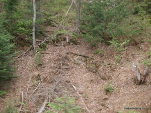
View from monolith
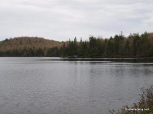
Initial view of Raven Lake
Staying along the western shoreline of Raven Lake is my current plan, traveling up near where the big wetland to the west resides for recording any possible bird species in this uniquely large wetland. I continue my way north along the shoreline towards that wetland, looking all the while for the perfect place to set-up camp. Once again, the feeling of untrammeled wilderness slightly evaporates when I catch sight of what appears to be a marked trail where none ought to be located.
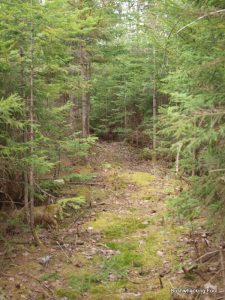
The trail leads west, as I can see several yellow plastic diamonds, each meticulously nailed onto trees along the undulating trail so the next one is always within sight of the last. Along with the markers are other signs of trail maintenance, including cut logs and tree branches. The larger cut logs imply the use of chainsaws, which are highly prohibited in the Five Ponds Wilderness Area. Apparently, this western leading trail heads to the Pepperbox Wilderness, perhaps meeting up with the older trail system south of Deer Pond.
Orange Trail
As I scan my surroundings, I realize I am standing on another trail, this one marked with orange plastic diamonds. It heads northwards in the direction I was traveling anyways, so I decide to follow it and see where it leads. The yellow one might come in handy for getting to the opposite side of the large wetland tomorrow during the Birdathon. Although I am supposed to be bushwhacking, it is difficult to look a gift horse in the mouth, especially when trying to find more than 50 bird species in a 24-hour period.
Soon another trail, this one also marked in yellow plastic diamonds leaves the orange trail and heads eastward, probably to Raven Lake’s western shore. Since it probably is very short, I decide to continue with the orange trail for a while, just to see where it goes.
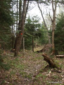
The orange trails then enters an area of dense young conifers, the way made infinitely easier by the narrow path carved through them for the trail. What looks like some discarded toilet paper lies in the trail, as well as a gallon-sized resealable plastic bag. I snag the plastic bag and stuff it in my pocket, but I leave the old toilet paper alone – there is a limit to my litter collecting after all. Some scat down the trail a ways, could be bear or might be human, looks like it is missing its toilet paper, but I leave that alone as well.
As I approach an opening in the trees, I enter an open wetland and find a surprising sight. An officially looking boardwalk disappears into the interior of the open wetland, suggesting an official New York State trail more than a hunters’ herd path. Although it could use a little maintenance, I decide to proceed and see where it ends.
Trail cut thru conifers
The boardwalk remains somewhat askew across a small stream in the middle of the wetland, apparently washed out by the spring melt. Somewhat freshly cut stumps are scattered about near the fractured bridge, suggesting some level of maintenance but apparently not enough to warrant fixing the bridge itself. Using the remnants of the bridge and the surrounding stream bank, I make the crossing without getting a wet foot, for which I am thankful.
The boardwalk quickly ends and the trail enters a hardwood forest, where the trail begins to gradually gain elevation as it continues northward. As I start approaching the point of me turning around, I begin to contemplate the trail’s inevitable end. Is it heading toward Muskrat Pond? Or does it connect to the New York State marked Canoe Carry (portage for those outside NY State) between Raven and Lyon Lake? Maybe both.
Unfortunately, it would remain a mystery, at least for this trip.
I retrace my steps back to the yellow marked trail heading toward Raven Lake. As suspected this yellow trail quickly ends at Raven Lake’s western shoreline, with a direct view to the private inholding to the east. It is understandable if one would picture a shabby shack here, but instead this “camp” looks nicer than many houses in the area. Meticulously kept, this three story home does not stand out too offensively, with its dark brown color and dark green trim. A boat house lies to the north of it, while a floating dock provides additional access to the lake. At least one outbuilding lies behind it to the south, looking more like a guest house than a garage or shed. A large porch allows for sitting out and getting eaten by mosquitoes during warm summer months.
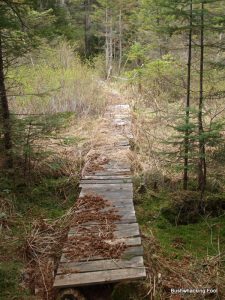
Boardwalk across wetland
This inholding is no stranger to me. On my first Birdathon back in 1998, I spent an evening on their porch. Hiking in along Raven Lake Road back then after a day of birding between here and my homestead in Oneida County, I found this inholding at the end of the road before I knew much about the area. A note was found on one of the outbuildings, inviting visitors to stay on the porch as long as they minded their manners, which I did for the night. It happened so long ago, it seems more dream than a memory at this point.
Near the end of the trail, I spot a red Mylar balloon, which I retrieve. After doing my duty here, I retreat back into the forest, looking for a good spot to set up camp. With the sky darkening and the smell of rain in the air, setting up camp suddenly takes up an air of urgency that it did not have just moments ago when I was reminiscing.
I find a nice spot for my tarp under some conifers just off the yellow trail, Raven Lake just barely visible through the forest. The usual camp chores ensued, setting up tarp, hanging food line, filtering water for tomorrow, and making dinner. At one point, a red-backed salamander crawls into and quickly out of one of my Crocs. Smart salamander.
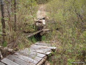
Bridge across stream
After the chores are complete, I return to the Raven Lake shoreline for an hour as darkness slowly takes over. A pair of common mergansers fly over, as do a pair of either mallards or American black ducks. A white-throated sparrow sings in the brush nearby. An unused yellow shotgun shell lies on the ground, which I pick up and place precariously in the crouch of a downed tree limb. A dog barking far to the south captures my attention; could this carry all the way from a campsite on the shore of Stillwater Reservoir?
At about eight o’clock, I retreat back to my tarp for the night. After writing some additional notes for the day, it is lights out, with my alarm set for midnight. My plan it to get up and listen to owls for a while at the very beginning of the Birdathon and then head back to sleep for a few more hours before getting up at around four in the morning.
That is, if it is not pouring rain out, and that I am physically able to get up so early.

Raven Lake camp
Affiliate Disclaimer: Some links and advertisements on this blog post and elsewhere on the Bushwhacking Fool may send you to a retailer’s website. If you chose to purchase any product on that site, this author may receive a small commission at no extra cost to you. These commissions provide compensation for the author’s time and effort necessary to provide the content at the Bushwhacking Fool. If you enjoy the content on the Bushwhacking Fool, please show your appreciation by purchasing products through links and advertisements on this site.


