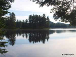
Witchhopple Lake
For the first time in years, the Red Horse Trail is once again under my feet. And it feels fine.
All it took me to get to this secluded trail was about two days of solid bushwhacking through the southern Five Ponds Wilderness. That, and a good deal of moxie. Typically, any sane person would reach the trail by boat, while those a little touched in the head (e.g. me!) would do so by trekking off-trail through some of the most remote area in the Adirondack Park. Although the hike down along the stream from lower Higby Twin Pond was easy enough for a bushwhack, hiking this trail is going to be nearly effortless, and quite liberating.
Too bad, it will not last long.
Although familiar, something about the trail seems out of sorts, at least based on my memory from past visits. The trail appears to go downstream for a short distance before retreating into the forest, where in the past it crossed closer to where I am now standing. I remember the crossing quite clearly, as it was a hodgepodge of log crossings over a few small grass islands, probably nearly impossible to cross during the spring runoff. At least that tricky crossing was better than what it was when I first came through here back in 1997, which required fording right across the stream without even a log bridge for assistance.
Instead of questioning the location, I hike downstream on the trail to see where it goes; probably not that greatest idea on a day when I am hell-bent on beating the rain, but what the Hell, you only live once. Apparently, not even the threat of rain can beat the curiosity out of me. In places the trail looks newer and less trammeled than is typical for a trail that has existed for nearly one hundred years or more.
Section Stats:
Date: June 27, 2015
Length: 0.7 miles (1.6 total daily miles; 14.0 total trip miles)
Difficulty: Easy
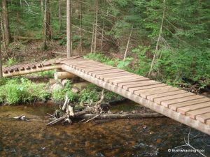
The trail retreats from the stream and veers off into the woods, though the stream remains visible to the east through the forest. After a short distance, the trail crosses a duel log bridge over a small wet area before going a short distance to another bridge over a small stream, apparently the one that acted as my guide from lower Higby Twin Pond. This bridge is made of wood planks nailed between two logs.
After another stint through the forest, the trail reaches a more significant duel log bridge over another stream. At least it starts out as two logs, but after a small wet area only the more significant log remains. The more significant log stretches across the Witchhopple outlet stream (Red Horse Creek?), its surface being carved so as to provide a roughly flat surface. The flat surface has a greenish tint to it, apparently the result of moss or algae growing along its length. The single log is thick and sturdy, bouncing only a slight amount in the middle as I cross.
On the far bank stands the stump from which this once majestic tree stood before being felled for this crossing. Though appreciating the dry crossing, a little bit of me feels sorry and regret that such an ancient sentry gave its life for me to avoid getting wet. I silently thank it and bow my head in appreciation.
This sturdy log is definitely better than the old crossing with several small log crossings being stitched together with some grassy islands. The log is now easily over a foot from the water surface, while being downstream makes the crossing less likely prone to disappearing during periods of flooding or snowmelt.
After crossing the bridge, the trail immediately climbs out of the floodplain, my legs welcoming the easy going compared to the bushwhacking I was just doing a short time ago. The trail winds through the forest, around this tree and then that one. Judging by the lack of a rut in the forest floor and the still present leaf litter, the trail appears new compared to ancient nature of the rest of the Red Horse Trail.
This new trail portion ends at a well-worn trail that I assume is the original Red Horse Trail. From this junction the original trail heads north-south, with Witchhopple Lake to the north based on the gaps between the trees. Southward is uninterrupted wetland and forest until reaching Salmon Pond, but that will have to wait for another three days on my return trip.
I head north, curious about the fate of the old trail section, now apparently a dead end. A nice campsite used to reside on Witchhopple Lake down this way, with the Red Horse Trail going right through its center. Perhaps the campsite is no more, but more likely this section now simply provides access to a more private place to camp now. After hiking for a short period, the trail descends to the old campsite, just as I remember it.

Witchhopple campsite
The Witchhopple campsite remains largely untouched by time, as it probably has for years. My first time visiting was back in May of 1997, and other than staying here for a few times that summer, this is only the second time I have been back.
A large fire ring lies in the site’s center, with the ground rising up onto a shallow ridge in every direction other than toward the lake’s western shore. Several layers of rock circle the ashy pit, with several charred logs stacked on top of each other to act as a wooden wall. A wooden spit hangs over the fire, apparently for cooking, while a bench made of a rock base and a heavy log sits not far on the opposite side.
Numerous flat areas lie along the shoreline, each completely clear of vegetation, just waiting for a tent. A few young fir trees still stand within the flat areas, somehow surviving the heavy use of the area. From the flat areas there are numerous places to approach the lake’s shoreline, which is gravel bottomed covered in a fine layer of algae.
Vegetation grows tall and thick on the opposite side of the fire ring, largely untouched by the activity around the campsite. The condition of the area suggests that larger groups occupied this site often in times past. The tall vegetation, hiding several logs and a few branches, suggests this side of the camp gets little use these days.

Trail to Red Horse Trail
Being on an aggressive schedule, I only rest for a short time to drink some water and take a few photographs. Despite my haste, I cannot stop myself from dropping my pack and continuing down the old trail to old stream crossing from years past. The gravel substrate that once allowed for fording is now covered in many layers of muck, or so I assume, as the dark waters prevent most light from penetrating. Most likely the beavers have been busy changing the nature of the outlet, first making the fording from my initial visit difficult, followed soon after by doing the same for the perilous island hopscotch, finally necessitating the current bridge well down stream.
Maybe in a few more years, there will be a steel suspension bridge; though probably not.
Returning to my backpack at the campsite, I collect all my gear and head back the way I came. However, before leaving I get my new video camera out of my backpack and attach it to my body using a chest harness so I can capture this part of my sojourn on video. This stretch of the Red Horse Trail will act as my testing ground for the camera, before using it for my bushwhack to Negro Lake. Video recording my bushwhacks will not only capture some of my bushwhack for viewing on YouTube, but also help me remember some of the more salient moments during my trips.
With everything set up and ready to go, I start the video camera and retrace my path back to the intersection, down the new section of the Red Horse Trail, crossing on the log bridge and finally back to where I hit the trail earlier. My plan is to head north a short ways until the trail crosses the inlet stream from the north and then head northeast to a more substantial inlet stream, which shall act as my guide all the way to Negro Lake.
Dog-legged Bridge
Heading up the trail, I stop for a short period where the old crossing existed based on an old path heading off south from the current trail. Whether that is the original fording site or the island crossing, I am not sure. Although the temptation to check it out is overwhelming, I continue northward on the main trail, hearing the trickle of a stream ahead.
After descending slightly, a sense of surprise overcomes me when I see another bridge crossing the stream. Another new bridge?!? This trail is experiencing a bridge boom! This bridge is an oddity though; as it has two legs to it, one that goes straight ahead and climbs over dry land, then it takes a jog and crosses the significant stream coming down from Clear Lake. A dog-legged bridge! A rarity in the Adirondacks to be sure.
Upon crossing the bridge, I stop for a quick break and decide that this point seems as good as any to start my bushwhack to Negro Lake. In a short distance northeast off the trail, another Witchhopple Lake inlet stream should provide a guide for me to reach the Negro Lake as it is its major outlet. Although I may not stay within sight of the stream, it shall provide some comfort just knowing that it is out there, guiding me forward in the correct direction.
With the hungry mosquitoes feasting on my exposed flesh and the rain clouds closing in ever so slowly, my rest is cut short and I step off the trail and head into the surrounding forest. If all goes well, in three days’ time, I will emerge from the forest onto the Red Horse Trail once again just south of Witchhopple Lake.
Wish me luck!
Affiliate Disclaimer: Some links and advertisements on this blog post and elsewhere on the Bushwhacking Fool may send you to a retailer’s website. If you chose to purchase any product on that site, this author may receive a small commission at no extra cost to you. These commissions provide compensation for the author’s time and effort necessary to provide the content at the Bushwhacking Fool. If you enjoy the content on the Bushwhacking Fool, please show your appreciation by purchasing products through links and advertisements on this site.


