Negro Lake
With the last Scattershot Pond under my bushwhacking belt, the time has come to move on and search for the old road that hugs the northern shore of Negro Lake in the southern Five Ponds Wilderness. It is mostly uninterrupted forest from here on out, so this last pond may be the last open water I see in a while, although conditions can easily change with all the beaver and water in the area.
I draw away from the last of the ponds, heading northeast and climbing steadily. The softwoods increase their influence in the surrounding forest as I cross a couple of small streams a short distance apart. The first stream appears as if it was created from recent intense runoff, with a plentiful supply of exposed organic soil, while the second is older, instead containing a continuous ribbon of exposed rocks.
Soon after the streams, hardwood trees dominate again, as if the two tree forms are fighting for supremacy of the forest. Another runoff stream comes along my path, which appears to give young conifers the upper hand as they appear more common now in the understory – the rulers of future forest perhaps. More exposed humus and piles of leaves in the area are evidence of intense rain showers in the recent past.
Section Stats:
Date: June 27, 2015
Length: 1.4 miles (6.4 total daily miles; 18.8 total trip miles)
Difficulty: Easy
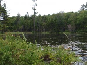
The young softwoods soon find their match in young hardwoods, as the young broadleaf trees reclaim control. In a short distance, a new competitor emerges in the form of large rocky outcroppings, complete with some rocky cliffs to the north. The cliffs are only about twenty feet high, with what appears to be a recently downed tree on top. A small puddle near the base of the cliffs allows leaving a few footprints, breadcrumbs to follow just in case someone is trying to find me in an emergency situation.
As I begin to descend from the rock cliff, the rough terrain becomes even more treacherous by the addition of some downed logs, trees uprooted due to the apparent thinness of the surrounding soils, and probably a good stiff wind too.
Descents follow accents repeatedly in a tiring pattern now, as I attempt to go through the col between a large shoulder of Summit Mountain to the north and a smaller shoulder peak to the south. One drainage seems to follow another with slight ascents in between, the first few descents being easy enough while the final one is more aggressive due to the rockier and rougher terrain. This last drainage contains an active stream, which I follow for a while despite all the hazardous rocks surrounding it, many semi-obscured by leaves.
As an open area approaches through the forest, I head downslope towards it, just to get a little peek. Although there is a little open water from where the previous stream enters the clearing, I barely glance at it, wanting to make good time getting to Negro Lake. Despite the desire, I decide to stop for a short rest in the forest off to the north a short while farther.
When the break ends, I continue on my northeast bearing, skirting the northern edge of the open area. The meadow is full of ferns and other herbaceous vegetation, and although it looks wet there appears to be very little open water other than a stream or two. Fortunately, the ground remains mostly firm close to the forest, so I keep along its edge for as far as I can without altering my heading.
As I pull away from the open wetland, the surrounding area becomes increasingly more forest-like, though the canopy seems to remain open to the south. The forest slowly becomes a mature mixture of hardwoods and softwoods, with many young trees in the understory, which makes drawing a bearing on something more difficult. On occasion the understory thins out, but before long it returns just as thicker as before.
An open area appears to the south, but I continue on my bearing, only catching sight of it through the trees. Negro Lake must be drawing near now, and my patience and interest in open wetlands has waned enough that it is suppressing of my inner photobug. The cloudy skies and forecast rain are keeping my focus on my immediate destination now.
Soon after crossing some rolling terrain with full tree cover, I start seeing the reflection of light off open water to the south. Negro Lake is finally within sight – at least, I hope so. I do my best to avoid immediately heading for the water, instead continuing northeast, remaining in the forest. This should give me the best chance of locating the remains of that old road that appears on my old map, and that I read about on the Internet.

Cliffs on way to Negro Lake
The surrounding forest becomes full of young trees now, making any attempt to get closer to the shoreline difficult anyways. It appears as if the forest is recovering from some past disturbance, like logging, which gives me hope that the road is near.
A small area mostly clear of saplings appears, so I stop for a short rest and drop my backpack now that my final destination is in sight. While resting, I wander about trying to find the location of the old road, which my GPS indicates is directly under my feet. After a short while of roaming about, I notice a slash cut in a young yellow birch right near where I put my backpack down, and then another a short distance away to the northeast.
Do these slashes indicate the presence of the road? It is my best clue so far. Well, actually the only clue to be honest.
Before pursuing this clue further, my curiosity gets the best of me and the thought of getting a good look at Negro Lake becomes my most immediate concern. After all this time searching for it since leaving the Red Horse Trail behind earlier this morning, it does not seem like it is too much to ask. My attempt to take the shortest path to the open water through the young trees is made easier without my backpack, which I leave behind at the suspected road.
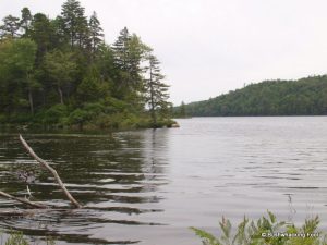
When I arrive at the shoreline, my location is at the western end of a mostly enclosed bay, making it difficult to judge the gigantic size of this large lake. Despite the limited view, the lake appears large, really large. An island to the east is barely visible around a ridge to the north, which forms much of the eastern portion of the bay.

Old Road North of Negro Lake
Backtracking to my original resting place is a slight uphill climb, made difficult from the numerous hummocks and hollows that make the landscape appear more like a war zone than a pleasant forest floor. These conditions, combining with the young, thick hardwood trees, imply a massive logging operation in this area in the not so distant past. This operation was most likely performed just before this property was sold to New York State, as is the usual procedure for wringing every penny out of land before handing it over for public ownership.
When I reach my previous resting position, I turn northeast and begin following the slashes carved in the surrounding trees when I can, the remnant of the road when I cannot. Much of the time the signs of the road are clearly visible, with an absence of larger trees combining with slight mounds on each side being the most obvious signs. This makes going a little easier than the bushwhacking from before but requires moving slower and more carefully, as I am constantly scanning the surrounding landscape for these signs.
The road starts descending slightly, apparently toward a clearing as an increasing amount of sky becomes more obvious within a thinning forest canopy ahead. The thicker young conifer growth in the middle of the road is another indication of this increasing amount of light, which means it is harder going, but if a wetland is ahead, it will only get worse.
North Bay on Negro Lake
The dreaded wetland becomes more apparent as I draw closer, as the forest gives way to an open area with equal parts open water and herbaceous vegetation. A pile of rocks now adds to the thicker tree cover within the old road, as if they were piled up to restrict further travel through the wetland. Rather than risk going through the wetland via the old road bed, I decide to bushwhack around it instead.
As I start around the wetland along a slope, I stop to look back to see if the road bed continues through the wetland. It seems like it might, but I cannot tell for sure as much of it is grown over, so I continue through the forest along the edge of wetland instead. The forest starts out fairly open, due to beaver activity near the water, but it quickly becomes thicker due to increased conifer growth.
When I get to the far side of the wetland, I decide to meet up with the road farther to the northeast rather than proceed along shore to meet up with the road at the crossing. With the inclement forecast, I do not have time for any backtracking, but finding the road again in the middle of the forest may turn out to be a challenge.
Despite the long day and impending rain, it appears my sense of adventure still remains intact. Let’s hope it stays that way.
Affiliate Disclaimer: Some links and advertisements on this blog post and elsewhere on the Bushwhacking Fool may send you to a retailer’s website. If you chose to purchase any product on that site, this author may receive a small commission at no extra cost to you. These commissions provide compensation for the author’s time and effort necessary to provide the content at the Bushwhacking Fool. If you enjoy the content on the Bushwhacking Fool, please show your appreciation by purchasing products through links and advertisements on this site.


